When Apple launched the iPhone in 2007, Google was a partner and not a competitor. Apple’s Maps, with data supplied by Google, was famously demoed by Steve Jobs when he searched for nearby Starbucks establishments and made a prank phone call with a tap of his finger. When Apple unveiled their iPad three years later in 2010, Steve Jobs was equally delighted to show off Maps, as he pinched the display to get a bigger overhead view of the Eiffel tower.
Initially, Maps was a simple mobile companion to Google Maps. Standard, hybrid, and satellite views were there, as was the ability to show traffic congestion and get driving directions between two locations of interest. It wasn’t until just over a year later with iOS 2.2 that Maps was improved with walking directions, public transit information, and street view. On the iPad, a terrain view was added. Alternate routes for directions came later in iOS 5 alongside estimated time of arrival and the ability to print directions via AirPrint. Over time, it became a robust Maps application that was better than Google Maps on the web.
What Apple did with Google Maps was pretty incredible when it was first introduced with the iPhone and later on the iPad. In contrast to using sliders and buttons on the web, Apple demonstrated that maps could be intuitive to navigate with just your fingertips. Panning around a map with your finger, tapping on search results to pull up business information, and navigating the world with Street View simply felt right on a touchscreen. Google provided often accurate search results and map data, while Apple provided a delightful interface to show their world through.
Today, using maps on our smartphones to find our way is an everyday habit. Frequent fliers rely on their smartphones to find their way in new locales, while city dwellers actively use smartphones to request public transit information. The convenience offered by our smartphones makes it possible for us to actively plan our days around city schedules, plan road trips, and get directions to a business for an all important interview. Beyond Apple’s Maps, companies like TomTom, Garmin, and Navigon added to the iPhone’s capabilities by providing real-time navigation and voice-guided directions through apps from the App Store. Yet competitors, such as Android with Google Maps and Google Maps Navigation, and Windows Phone 7 with Bing Maps and Nokia Drive, were offering GPS navigation on their ecosystems for free. For iOS 6, the missing piece to be filled-in for Apple’s Maps would have to be such a feature.
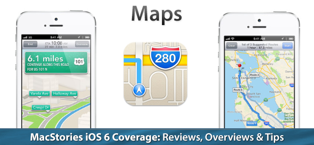
In iOS 6, Apple’s Maps is a headlining feature. During this year’s WWDC 2012 Keynote on June 11th, turn-by-turn navigation was showcased for Apple’s brand new Maps application in concert with the display of real-time traffic conditions. Apple added interactive 3D views and Flyover to select cities, giving maps a 3rd dimension on top of a traditional satellite view. As impressive as Apple’s demonstrations were, the most interesting feature are Apple’s new vector based maps, completely redesigned “from the ground up” as a replacement for Google’s Map data.
Apple’s own.
I have no complaints about Google’s map data. Search results are often very accurate, business listings are up to date, directions and alternate route choices are good, and even if the satellite views haven’t been updated in a while, the standard view does a good job of showing up to date information amongst road changes and the construction of new business plazas in and around my town. Maps is an app I frequently use, and Google has done an excellent job of earning my trust over the years as a maps provider.
But as Google became an iPhone competitor with the proliferation of Android, Apple sought to sever ties with Google’s implementations. The marriage was over. In iOS 6, little trace of Google’s presence remains with the exception of Google being the default search engine in Safari. This means that Maps no longer provides Google Maps search results, their top notch satellite imagery, Street View, or Google’s excellent transit data.
Apple, utilizing a consortium of partners and taking advantage of previous acquisitions such as Placebase, Poly9, and C3 Technologies, have drawn their own map of the world. Maps feels rejuvenated, in part because of Apple’s excellent cartography, and in part because of Apple’s always profound attention to improving the user experience. In their presentation, Apple’s eye for detail has certainly created what I think is the most beautiful maps app on any mobile OS.
Behind Apple’s Maps, however, I have a lot of mixed feelings about the source map and navigational data. TomTom is listed as the primary provider, with numerous other partners listed in the app’s acknowledgements. As Noam Bardin said to Business Insider, “Apple went out and partnered with the weakest player,” adding that people may have trouble finding points of interest as a result. I have the same reservations, considering that Maps, in many instances, provides many inaccurate Local Search results.
Results may vary.
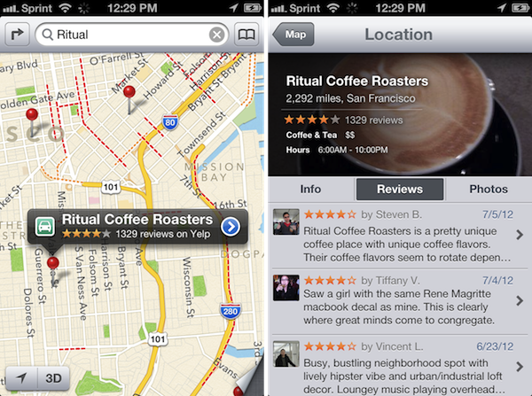
For Local Search, Maps does its best to find things around you that are relevant to your search terms. Like in Safari there’s predictive search, meaning you’ll see a history of what you searched for underneath assumed keywords and business name matches as you type in the search bar. It’s a nice touch, but the search results themselves can be rather iffy.
What’s interesting is that while Maps can often find what I’m searching for, it sometimes doesn’t exactly pinpoint where it is, and sometimes it takes multiple tries with slightly different keywords. A car dealership I was visiting one afternoon was listed on the wrong side of the road. A gas station at the corner of a major intersection in my town is listed as being diagonally opposite of where it actually is. Yet Maps can pinpoint the entrance of a Target store in a shopping complex where standard road mappings are missing. At the same time, it can’t put a pin on a department store in the same complex. It won’t find public parking for a bus station in my town, but Maps will instead zoom out to show me public parking decks for a major city sixteen miles away. If I zoom out far enough, searching for grocery stores shows me exactly where all of the grocers are in my town. Results may vary.
For example, searching for pharmacies brings up one drug store in my town, but not the other. While it will list an in-store pharmacy for Target, it won’t for the grocery store next to it. The same can be said for other nearby shopping complexes. Specific search results usually yield better results in this instance, such as specifically naming the drug store in question. In comparison, a general search on Google Maps is much more aggressive (it includes all of the locations Apple’s Maps misses, plus pediatrics and local medical centers). Waze on the other hand forgoes in-store pharmacies and instead only shows the big retail chain drug stores, such as CVS, Rite Aid, and Walgreens.
In another instance, let’s look at how Apple looks up gas stations. In querying for gas stations, Maps will zoom out and show me one or two gas stations in my town, but not all of them (there are several). After taping the geolocate button, if I search for local stations by gas company, à la BP or Shell, it doesn’t always show every BP or Shell station in my town. But if I pinch out and search for gas again, it’ll drop pins on more gas stations, but still not all of them. Which is weird — why does searching for public parking take me miles aways, but Maps won’t bother to zoom out to show me nearby gas stations? Google Maps does a better job with local results, but it also misses some gas stations. Waze does an incredible job here, showing not only all of the gas stations in my town, but also the gas prices for regular in the convenient pop-ups. There are big benefits to crowd sourcing map data and rewarding users it seems.
Searching for banks turned up positive hits. Local credit unions were found alongside expected big branches. Searching for department stores was a mixed bag — sporting goods and clothing stores should show up right? Searching for tools oddly brought up local businesses such as Rubbermaid (just an office here), but doesn’t bring up the local Lowes or Home Depot. More specifically, a search for home improvement only brought up Lowes. A search for gardening? It zoomed out to find a construction company, an environmentally friendly advocacy group, but not any nursery or landscaping services. I give up. What was great about Google Maps is that it could infer what I’m looking for, and even if it searches aggressively, could usually get what I wanted.
The best way I can summarize Apple’s Maps is that it knows about what’s out there — clearly Scott Forstall wasn’t joking when he said that they have 100 million business listings in their database — but it feels like the pointers to those businesses just aren’t there. It’s good at getting you in the ballpark of where something is, and it works best if you’re explicitly looking up the name or address of a business. Although in Chris’ case, he did have a hiccup where it took him a mile away from his actual destination (with walking directions). I imagine Apple’s Maps are more concise in major population hubs like San Francisco, while American suburbs across the country will probably need lots of work. Based on feedback from Federico and Graham (whom live in Italy and Australia respectively), international maps data will be hit or miss as well.
Download these extra these things. Please.
The big letdown I think, especially for international Maps users who rely on public transportation much much more than Americans do, will be the absence of Google’s public in-app transit data. The bus icon for directions is still in Maps, although a search reveals that Apple will redirect users to a section of the app store for routing apps. Apple has decided to let developers fill in the gap with their own transit apps on the App Store, which is a good thing for small businesses, but a bad thing for iPhone users considering the previous Maps app had it baked in. Apps like Transit will become the saving grace for iPhone owners who frequently use public transportation.
The big beneficiary of Maps will definitely be Yelp — no questions asked. When you tap on a local business, you’ll enter a card view which aggregates business information alongside pictures and reviews from Yelp. I was surprised and impressed to find lots of pictures and reviews for local businesses — there were even reviews for a nearby park and mountain bike trail. In order to read all of the reviews, you have to download the Yelp app. Not being a Yelp user or one who wants to check into places, I’m not really interested in making an account or downloading the app, and I’d rather not leave Maps, but I kind of have to know if the establishment I’m eating at is going to serve good food or not just to name one concern. Really though, it’s no different than how Siri handles Yelp reviews, which I’m not really happy with.
Hey Siri, can you find me a gas station?
Siri has gotten a lot better at understanding me since the launch of iOS 5. Which is good, since with iOS 6, it’s integrated with Maps so that I can ask it to find nearby gas stations or hotels while I’m driving (which can be super useful when traveling). Siri’s results will sometimes leave out a gas station or two as noted with Local Search above, but when I’m in need of gas, having a gas station vs. having the gas station of my choice is probably more important. And yes, you can ask it, “Are we there yet?”
Largely, I’d say Siri’s accuracy in finding local businesses is about the same as Local Search. It understands context better, but at the same time it only applies its logic in certain situations. Ask Siri to find a dentist office for example (just generically). It’ll pull up a bunch of local listings. I then asked it to take me to a specific dentist office in that listing (not by tapping the result, but by asking by voice). It took me to a town in Florida (States away!), and once set, only wanted to show results in that area. I asked it to find dentist offices “near me,” and it looked for dentists in Maine. I couldn’t catch a break. When I asked it to find the specific dentist office “near my location,” it finally found it. I still can’t believe the “near me” command didn’t work.
Siri is picky, but is super useful for navigation, especially if where you want to go is listed in your contacts. Ask Siri for directions to your parent’s house, and provided you’ve listed your mother or father as your parents, Siri will immediately give you directions. Work directions? Easy. Traveled far and want to go home? Upon commanding Siri to “Navigate home,” Maps will spring open and launch turn-by-turn directions, showing you the path back home. That stuff works really well.
Turn-by-turn directions.
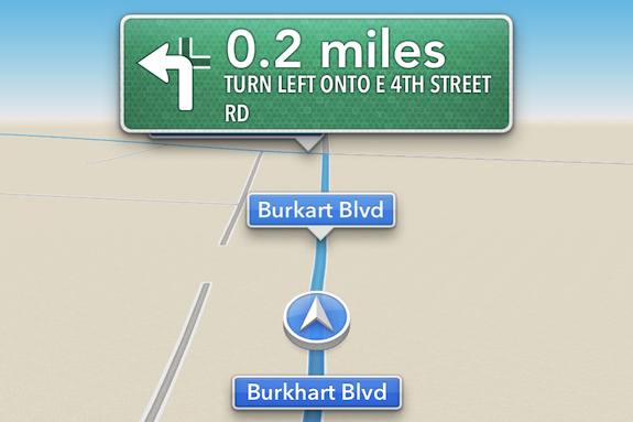
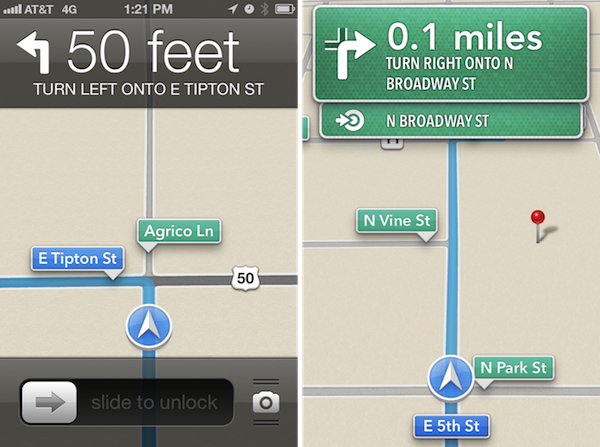
This is my favorite feature in the iOS 6. Turn-by-turn directions are incredibly well done, accuracy of searches and destinations aside. Turn-by-turn directions are presented in full-screen, and when tapped, drops down the top bar to show you your estimated time of arrival. When you reach your destination, the top bar is automatically revealed so that you may end your trip. Map directions are even display on the lock screen. Even cooler — if you’re at the Home screen or inside another app, banner notifications will appear to indicate an upcoming turn.
Voice-guided directions give you plenty of time to prepare for a turn, and Maps will show you multiple turns in advance if you’re going to be making multiple, subsequent turns at intersections. The maps are easy to follow, beautifully laid out, and in supported cities, 3D views will give you a sense of place. I can not talk highly enough about the presentation of the app — it’s really pretty.
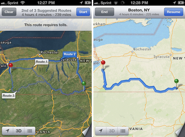
I think there are some key pieces still missing, however, where competitors will still have the advantage. As pretty as turn-by-turn directions are, options to avoid highways and tolls are important, as is the ability to choose shortest route over the quickest. Apple’s Maps loves highways, and will do anything to keep you on one, even if you’re intentionally taking a back road (it’s as if the re-routing algorithm was practically begging me to get on a major highway). There are good alternate choices for most destinations, although there’s sometimes weird “glitches” where for longer travels, a route will seemingly jump off the highway onto other roads only to get you back on a later point. I don’t think that’s because of traffic congestion either — I’m pretty sure it’s the algorithm. I wonder though, if during the trip, whether Maps will decide to keep you on the highway since the ETA would be calculated to be faster that way. Maps is supposed to re-route you around traffic congestion (based on ETA) when possible, so it should apply to this instance right?
Apple says they’ll show you traffic data in real time, and they’ll even pop up icons to indicate accidents, road construction, and other incidents. In the list of Apple’s partners is Waze, although Waze themselves haven’t publicly stated how they’re involved. During the WWDC 2012 Keynote, Scott Forstall said, “In addition to other data sources, we’re using anonymous real-time crowd-sourced data right from our iOS users to keep this traffic fresh and up-to-date.” That got a nice applause. Although, where is this data coming from? I can’t report incidents, at least in this version of Maps. I’m not actively doing anything. So how does it know where the problems lie (more specifically, what they are) beyond traffic congestion? How am I, as an iOS user, contributing to Maps’ traffic data? Of Apple’s partners listed, the only one I know of that does crowd-sourced traffic data, and has lots of users to back it up, is Waze. That’s my guess.
Flyover, 3D maps, and Apple’s cartography.
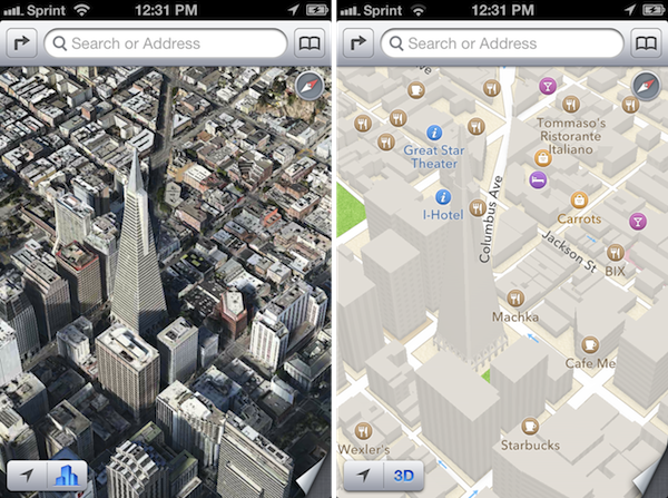
Flyover is interesting. It’s a feature Apple is really proud of, but getting it to work is tricky. Watching Scott Forstall’s demo, I noticed it worked for him only when he was already in the satellite view (it works for the hybrid view too). But the key was that he tapped a bookmark — the Transamerica Pyramid in his case — and it took him to that building before flying him around. It’s akin to being in a helicopter circling a building. The effect is cool, although I could only get it to work when 3D views were already enabled (I imagine that’s not supposed to be the case, since Flyover begins in a 2D overview). Is the feature gimmicky? Maybe. I honestly don’t see the benefit of it, considering you have to have the bookmark for the place you want to Flyover before it will work. I couldn’t get Flyover to initiate with any specific Local Searches. If I have to seek out a place I want to visit myself before I can bookmark it, why would I want to get a Flyover later?
What I’m not sure of is whether Flyover for Apple’s Maps also applies to the general 3D rendering of buildings in their satellite view. Federico says that the rotating animation I described above is just an implementation detail, whereas I think “interactive 3D views” encompass everything from the 3D renderings of buildings in the standard views (where buildings look like big vector blocks), 3D renderings of buildings during navigation, and also the 3D renderings of buildings in the satellite views as you tilt and pan around in supported cities.
The interactive 3D views are neat to see in supported cities. These 3D views will show buildings in vector-based outlines to give you a sense of place, but more often, will offer only a 3D representation of a city in the satellite view. Apple’s vector based maps look excellent, but their 3D imagery of cities such as Munich, Germany, and Milan, Italy lack the same kinds of detail I found in bigger American cities. In my opinion, these 3D views aren’t as useful as Google’s Street View, which lets you put virtual boots on the ground so you can get actual photos of a location and pick out specific landmarks and road signs, whereas Apple’s photorealistic images don’t nearly show the same levels of detail in an overview.
Apple’s satellite imagery is very different from Google’s. It could just be my locale (I didn’t have the same complaints browsing Appalachian mountain trails), and maybe I’m nitpicking here, but Apple’s satellite imagery looks browner. The satellite images of my town make it look like all of the grass and trees are dead. I’m not a fan of the satellite imagery. Everything’s greener (and I think more accurate as far as color goes) in Google Maps. In all fairness, however, Apple’s satellite images are more up to date than Google’s where I live.
I do think Apple did a fantastic job with their cartography. Google’s maps are very detailed, attempting to convey everything that’s around you all at once. Apple’s maps — which are beautiful — feel much lighter and give you a much broader overview. Everything feels precise. As you pinch into a location, badges will start appearing to show you restaurants, gas stations, banks, and other points of interest that exist. Zoom in further, and you’ll start seeing more businesses appear, alongside traffic directions and road names. It’s an interesting effect, and I think one of personal taste. Google Maps is going to show you more information when you’re zoomed out, but it’s cluttered. With Apple’s Maps, you have to zoom in much more and pan around, but it’s much easier to see where everything is. I’m not exactly sure how Apple determines what businesses or places show up first as you zoom in and out of cities, but everything Apple draws on screen in their standard view is tastefully done. Their color choices, how roads are drawn, how they handle the outlines of buildings — it’s much more pleasing to look at than other map solutions. There’s also those little implementation details: rotate the display, and the text labels for businesses rotate with you. So cool.
Apple’s got a long way to go. They can do it.
In my opinion, Apple has nailed the presentation of their Maps app. The new icon looks fantastic, Apple’s cartography is stunning, and their 3D imagery is for the most part, top notch. I’m really a fan of Apple’s turn-by-turn directions. Critics are going to argue that Google still has the upper hand here, especially for 3D imagery when pitted against Google Earth, and I’d agree, except that Google Earth constantly gives me low memory warnings and crashes on iOS. Google is said to be working on their own Maps app for the iPhone and iPad, although I’m surprised it isn’t out preceding the launch of iOS 6.
What I’m not a fan of is the data. My results of course are going to differ from people around the world, but as someone who was spoiled by the accuracy of Google Maps, I’m constantly frustrated by Maps results. I feel I can’t trust Maps — if it’s getting business locations wrong for my town, how do I know it’s going to get me to the right place when I’m traveling? It’ll hopefully get me the ballpark, but if a building is said to be on the wrong side of the road, that can be disorienting and dangerous while driving. I shouldn’t have to worry about this stuff.
I think Apple is certainly capable of patching their data, improving their results, and using feedback from iOS users to fix problems. Over the next years I bet these results will get much better. (You can certainly make good use of the report button in Maps). I think in some instances it’s a step backwards. People had readily available transit data, they had good map results, and now those results are replaced with inferior data or nothing at all. I mean that — I wouldn’t say it if I didn’t believe it. A developer in the App Store would get skewered if they removed features users paid for in their apps. People don’t care (and probably don’t know) about the spat between Apple and Google; people just want the accurate results they’re used to. The problem, as I see it, is that Apple doesn’t have a solution that’s equal to Google Maps data. I joke, but pretty soon Google’s going to have self-driving Google Cars mapping the world. The real threat is obvious — Google’s a data company. Plain and simple, they’re pros at this mapping stuff. Apple is starting at square one.


