Posts tagged with "maps"

Apple Details iOS 6 Feature Availability By Country

As noted by Horace Dediu, Apple has published an official list of iOS 6 feature availability on its website. While iOS 6 is officially coming out next week, on September 19th, not every feature will be available in every country.

The list focuses mainly on Siri, Maps, and Dictation. Availability of iTunes Store and App Store content is mentioned as well, but that’s not really new if you’ve been following the expansion of Apple’s digital storefronts in the past months. What’s interesting ahead of iOS 6’s launch is the list of features that, due to content limitations or the “beta” nature of Siri, won’t be available in some parts of the world.

For instance, Maps’ “standard” operation will be available from Afghanistan to Zimbabwe for a total of 181 supported countries. This should include the “standard” view of Maps – the new tiles that Apple is using after removing Google’s ones from iOS 6 entirely. Similarly, the Satellite view of Maps will be available in the same 181 countries worldwide. However, things start getting different with Maps’ Directions and and Turn-by-Turn navigation: the former will be available in 96 countries, the latter in 56. 3D buildings, another feature of Maps, will only be available in the United States at launch, whereas Traffic information will be available in 23 countries. Last, Maps Local Search will be available in 49 countries, and Business Reviews and Photos in 15.

Siri is even more limited. In spite of the voice assistant gaining support for more languages in iOS 6, several functionalities and integrations will be limited by the user’s location. So, for instance, while everyone will be able to set Siri to a supported language and issue commands, Sports data will be limited to 15 countries; Twitter and Facebook integration to 14; Local Search and Restaurant Information to 10, but Restaurant Reviews will only be available through Siri in 9 countries and Reservations in 3 (USA, Canada, Mexico). Another Siri integration, Movies, will be limited to 13 countries for Movie Information, 4 for Reviews, and only 3 for showtimes.

As Apple embraces more third-party services in its operating systems, it’s no surprise that some features will be restricted to only the countries where those services are fully operational. The same happened with the first version of Siri last year – some commands were only supported in the United States initially.

Check out the full list of iOS 6 feature availability here.


New iOS 6 Maps App To “Blow Your Head Off”

New iOS 6 Maps App To “Blow Your Head Off”

John Paczkowski at All Things Digital confirms a rumor published this morning by Mark Gurman at 9to5mac: Apple’s forthcoming iOS 6, set to be announced at WWDC, will feature a new Maps application based off Apple’s new mapping backend.

We’ve independently confirmed that this is indeed the case. Sources describe the new Maps app as a forthcoming tent-pole feature of iOS that will, in the words of one, “blow your head off.” I’m not quite sure what that means, and the source in question declined to elaborate, but it’s likely a reference to the photorealistic 3-D mapping tech Apple acquired when it purchased C3 Technologies.

That Apple was going to replace Google Maps with a different technology – and quite possibly its own – is nothing new, at least from a rumor perspective. In the past years, a series of tidbits of information and facts seemed to suggest that Apple was on track to deliver a different Maps application for iOS in the future. Last summer, a series of legal disclaimers pointed at various mapping technologies being used by Apple in iOS, but the rumored new mapping tech that was allegedly meant for iOS 5 didn’t ship with the major update in October, as Apple and Google renewed a deal to use Google Maps in iOS.

In April 2011, Apple confirmed they were “collecting anonymous traffic data to build a crowd-sourced traffic database”, although without specifying whether such service could see a public implementation in a new Maps app for iOS. More than a year ago, we wrote how “in the past years, several job listings on Apple’s website hinted at open positions in the iOS team for map engineers and navigation experts, suggesting that Apple was working on its own proprietary solution to ditch Google Maps on the iPhone, iPod touch and iPad. The acquisitions of mapping companies Placebase and Poly9 in 2009 and 2010, respectively, gave some credence to the reports that pointed at Apple willing to become the next major player in the mobile mapping scene.”

Most recently, Apple officially acknowledged they are using OpenStreetMap data in iPhoto for iOS.

Permalink

Add a Speedometer to Maps in iOS

Traveling at the speed of light? Measure just how fast you’re going with a speedometer you can add to the Maps app via a Cydia tweak for Jailbroken iPhones. Speed for Maps is a small utility that you download to measure how fast you’re traveling in miles per hour, feet per second, kilometers per hour, meters per second, or knots if you’re traveling the high seas. A small, circular badge is added to Maps that displays your current speed — useful for biking and boating, but maybe not so much for driving where your panel instruments already give you everything you need. Regardless, it’s a simple tweak you can find in the Cydia repository if you’re interested in adding the tiny overlay.

[via FunkySpaceMonkey]


Legal Disclaimer In iOS 5 Further Hints At Apple Mapping Service

Tipped off by a reader, MacRumors has found that the legal disclaimers in iOS 5 contain new references to a number of third party companies that provide various mapping services. The disclaimers come under a new section called “Map Data” that is not present in previous disclaimers and is completely separate to the section which deals in the disclaimer which deals with licenses used by Google for its mapping service that is used by Apple in the Maps app.

Today’s discovery comes after a number of other revelations, together they form what seems to be the suggestion that Apple is looking (or potentially actively working on) its own mapping solution that could replace Google Maps on iOS. Some of those clues include its acquisition of mapping companies Placebase and Poly9 and its recruitment of employees with navigation software expertise. The location log debacle also revealed that Apple was “collecting anonymous traffic data to build a crowd-sourced traffic database”.

MacRumors had a look into all the companies newly listed in the legal disclaimer and gave a quick description of each of them (included below). Noting two companies in particular that suggest Apple may be developing its own maps service. Urban Mapping provides some extensive additional data such as a wide range of demographic information that can be layed on top of traditional data. Waze, however, is experienced in developing crowd-sourced traffic data - it also has a popular app in the App Store now which demonstrates a lot of their services.

  • CoreLogic offers Parcel data which marks boundaries for of properties to provide positional accuracy in location-based solutions.
  • Getchee provides location and market data on China, India and Southeast Asia.
  • Increment P Corp provides location and traffic data for Japan.
  • Localeze provides local business listings.
  • MapData Sciences Pty Ltd. Inc provides mapping data for Australia and New Zealand.
  • DMTI provides postal code data for Canada.
  • TomTom offers global TeleAtlas mapping data which is also licensed by Google for their map solution.
  • Urban Mapping provides in-depth neighborhood data such as crime, demographics, school performance, economic indicators and more.
  • Waze offers real-time maps and traffic information based on crowd sourced data.

Whilst this doesn’t provide concrete proof of whether Apple is working on its own mapping service, we are fairly sure it (if it exists) will not be launching with iOS 5. This is likely related to the fact that Google recently renewed its agreement with Apple to provide Google Maps to iOS.

Jump the break to see some screenshots of the new legal disclaimer which features these new companies.

[Via MacRumors]

Read more


Google Renews Maps Deal With Apple, Plus Other Tidbits From Schmidt’s D9 Appearance

Last night the annual D9 conference kicked off with an interview with Google’s Executive Chairman, Eric Schmidt. It led to a number of interesting revelations, perhaps of most significance is that he revealed Google has “just renewed [their] Map and Search agreements with Apple”.

The renewal of the Maps agreement confirms rumors we reported on last week where it was suggested that although Apple is looking to improve the iOS Maps application, it would not replace the Google service that powers it. Speculation about Apple launching their own Maps service was ignited last month after Apple posted the location tracking Q&A post, which talked of a crowd-sourced service to improve traffic information.

Speaking of the new platform war, fundamentally based on the Internet, Shmidt said there is, primarily, a gang of four that includes Google, Apple, Amazon and Facebook. He says that whilst there may be a debate about who is fifth and sixth (suggesting perhaps PayPal and Twitter), it is pretty clear that Microsoft is not included. Asked why, he says Microsoft is not driving the consumer revolution – they are focused on corporate and are doing so successfully – something that will likely continue for decades to come.

Whilst talking about the Chrome OS, Schmidt took off on a tangent and claimed that Chrome was a more secure browser. Then when prodded by Walt Mossberg on what else users could do to improve security, Schmidt said they “could use a Mac instead of a PC”, citing the observation that viruses are less likely to affect users.

When Google launched its cloud music offering, many were disappointed that it was just a locker for music to be stored, with no way to purchase music directly. Asked why Google failed at signing with any of the record labels, Schmidt simply says, “I’ve just not been successful in doing that”. Finally, make sure to jump the break to watch the (fictional) acting-CEO of News Corp, Jane Lynch, launch the D9 conference, with some jabs at The Daily and other News Corp entities.

[Via AllThingsD]


iOS 5 Won’t Feature Apple’s Maps Service, Google Maps Still In?

Following today’s reports on iOS 5 coming with completely revamped notifications and widgets, 9to5google claims the next major version of iOS 5 won’t feature the maps service Apple was rumored to be working on, but it will keep using Google Maps as in the current versions of iOS.

Now, sources have told 9to5Google that although Apple is working to improve the iOS Maps application, iOS 5 will not bring an Apple developed maps service and Google Maps is still in. Besides Apple’s purchase of both Placebase and Poly9, some speculated that Apple is building their own maps service to either compete with Google or step away from their input into iOS.

The speculation on a map service developed by Apple to replace Google Maps integration on iOS devices indeed started after the company purchased Poly9 and Placebase – two companies focused on mapping softwares and location databases – also followed by various job postings Apple put up on its site, asking for map engineers and navigation experts to bring Maps for iOS “to the next level.” Putting this information together, many believed Apple skipped iOS 4 only to bring its new and improved maps to iOS 5, set to become publicly available later this year, perhaps in the Fall. Apple also briefly mentioned in the location tracking Q&A that they’re building an “improved traffic service” to launch in the next couple of years, giving more credence to the reports of Apple developing its own system, rather than an additional layer to Google Maps.

Others also suggested the disputes between Steve Jobs and former Google CEO Eric Schmidt, as well as the competition with Android might be the reason behind Apple’s intention to drop Google Maps from iOS. While it might be true that Apple would rather use its own map solution rather than someone else’s, it’s worth noting that Google Maps is the de-facto solution for online maps (used by millions of users every day) and other Google services are embedded in iOS, such as Gmail integration and search.


Maps+ Enhances Google Maps On iOS

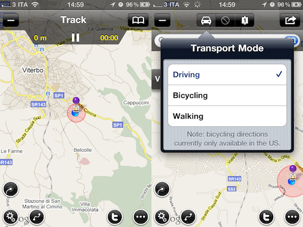
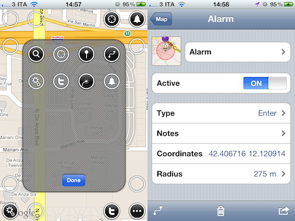
Maps+ by IZE, released earlier today in the App Store for iPhone and iPad, is a new free application that aims at enhancing the standard iOS map experience by plugging directly into Google Maps and adding several new features and interface improvements that turn the mapping software into a powerful location and social sharing tool. Maps+ supports Google Maps’ standard views (standard, satellite, hybrid, terrain) and allows you to quickly switch between them with a vertical three-finger swipe that may result unintuitive on the iPhone, but works really well on the iPad. What impressed me about Maps+ upon first launch is the way the app lets you customize the buttons that will overlay the standard map. From a translucent editing interface, you can drag buttons (settings, alarms, fetch position, Twitter, route and track) onto the map in pre-selected spots running along the top and the corners of the map screen.

Maps+ can get your current position, as well as search for specific addresses. Once you’ve found an address on Google Map, Maps+ can get you there with directions for driving, walking and bicycling (the selection happens from an iPad-like popover menu), give you different routes and check out the destination point in greater detail from a dedicated screen. Here, you can choose to “route here” or “drop pin”, add the place to your bookmarks, copy or mail the link and even export to GPX for viewing this information on your computer or other compatible apps. There’s more: you can use location-based alarms to be notified when you hit a place of particular interest and, if your device supports multitasking, alarm monitoring and (another feature of Maps) GPS track recording will work in the background. Among all the little additions to Google Maps and the functionalities you can check in the full app description on iTunes, one that really surprised me is Twitter integration within maps: thanks to Twitter’s geolocation support, once logged in with Maps+ you’ll be able to see your friends and people you follow on a Map, see who replied to you and where and even report spammers from Maps+. The developers describe it as a complete Twitter client, only displayed on a map.

Maps+ is free, but some features need to be unlocked at $2.99 via in-app purchase. Here’s what you get with the free edition:

  • Labels are limited to 1.
  • Pin bookmarks are limited to 3.
  • Route bookmarks are limited to 1.
  • Route transit points are limited to 2.
  • Track bookmarks are limited to 1.
  • Track recording is limited to 2 km.
  • Alarm bookmarks are limited to 1.
  • Importing bookmarks from GPX is disabled.
  • Logging in to Twitter is disabled.

If you’re serious about maps on your iOS device, forget the Google Maps webapp and Apple’s own application and go get Maps+ now. It’s powerful, well-designed, easy to use and Twitter integration adds a lot of value, and a welcome social aspect.


Google Completely Revamps Maps on Mobile Browsers

Announced a few minutes ago on the official Google Mobile Blog, the Maps web app for iOS and Android devices has gone under a major update that enables new features and menus when viewed on mobile browsers. As Google reports, 40% of Maps usage happens on mobile browsers, and that’s why the company decided to update the maps.google.com website to offer a more consistent experience across smartphones and tablets. The changes, however, are exclusive to the web app and we can’t see anything new on the native Maps app for iOS, which uses Google’s backend but is developed by Apple.

The new Maps website displays a bar on top to get your current location, enable and disable layers like satellite, labels, traffic and points of interest, and another button to get directions to a specific location or learn more about places that support additional information and photos (like restaurants). Provided you give Safari access to your location, you can easily get directions as you would on a desktop browser, sign out of your Google account and access the “My Maps” interface from Google.

Now, when you visit maps.google.com on your phone or tablet’s browser and opt-in to share your location, you can use many of the same Google Maps features you’re used to from the desktop.

The new features include:

  • See your current location
  • Search for what’s nearby with suggest and auto complete
  • Have clickable icons of popular businesses and transit stations
  • Get driving, transit, biking, and walking directions
  • Turn on satellite, transit, traffic, biking, and other layers
  • View Place pages with photos, ratings, hours, and more
  • When signed into your Google account, access your starred locations and My Maps

You can try new Maps mobile website by heading over to maps.google.com on your iOS or Android device. Check out more screenshots below. Read more


“New and Innovative Features” Coming to iOS Maps App, According to Job Posting

It’s no secret Apple is working on new functionalities for its iPhone and iPad Maps application to introduce in iOS 5, but a new job posting on Apple’s website seems to confirm that the focus for the next major version of Maps will a completely new user interface, and a series of “innovative features” that, supposedly, will dramatically change the look and feel of the app. Apple already emphasized in the past through other job postings that they were looking for engineers to bring Maps “to the next level” with deeper integration with navigation software, so it doesn’t come as a surprise that the team is still looking for new designers and developers to enhance the Maps experience.

Come work for the team that revolutionized the mobile technology industry as it continues to define what computing looks like in a post-PC era. The Maps team is looking for a proactive and hardworking software engineer to join our team. Along with excellent skills in object-oriented software design and programming, the successful candidate will have real-world experience developing sophisticated user interfaces. Excellent communication skills are also a must, as you will be collaborating closely with Apple’s peerless human interface team to add new and innovative features.

Whether the new version of Maps will be bundled with iOS 5 is still unknown at this point; Apple confirmed last week that they are currently working on an improved traffic service to launch in the next years, but several reports in the past indicated iOS 5 – coming out later this year, with a preview at the WWDC in June – would be heavily based on location, Maps, and other cloud-oriented features. Many even speculated Apple could leverage its own version of mapping software, thus ditching Google Maps, to build a new social location service to include in the new MobileMe / iCloud. Speculation about the new iOS Maps application is running wild lately, and the job postings from Apple do nothing but increase the amount of guesses and rumors we’re hearing on the subject. Seeing an improved Maps app in June wouldn’t surprise anyone, but it’s unclear how many of the new functionalities Apple is working on will be rolled out this year with iOS 5. [via 9to5mac]