This Week's Sponsor:

PowerPhotos

The Ultimate Toolbox for Photos on the Mac


Posts tagged with "maps"

Developer Gets First iOS 5 Crash Report, Hints At New Map APIs

FutureTap, developer of popular augmented reality app for iPhone Where To? we covered here, received earlier today a crash report coming from a device running iOS 5. The crash report, also posted online, doesn’t come as a total surprise in the way it confirms Apple is field-testing the new OS internally with App Store applications; however, a selector named MKUserLocationBreadCrumb indicated as the cause of the crash seems to suggest Apple made some changes in the location and map APIs, as widely speculated.

Just received the first iOS 5.0 crash report. MKUserLocationBreadCrumb sounds interesting.

Already fixed the iOS 5 crash. Now the big question: Mention in the update notes?

No further technical details have been provided by the developers, but it appears that changes made in the map APIs for iOS 5 (still referred to as “iPhone OS 5.0” in the report) may cause obvious incompatibilities with current iOS 4-based apps. Apple is expected to officially introduce iOS 5 at the WWDC ‘11 in June; rumors in the past weeks claimed Apple would offer an on-stage demo, as well as first developer betas soon after the main event. Virtual assistant software Siri, bought by Apple last year, is rumored to play a big role in iOS 5, alongside new cloud, social and location-based features. [via 9to5mac]


Apple, Location Services & The “Improved Traffic Service”

In Apple’s official response to the location tracking issue uncovered by security researchers last week, an interesting tidbit seems to confirm that the company is seriously committed to delivering improved mapping and navigation software to iPhone users by focusing on building a new “traffic service” to roll out publicly in the next couple of years. From the Q&A:

What other location data is Apple collecting from the iPhone besides crowd-sourced Wi-Fi hotspot and cell tower data?

Apple is now collecting anonymous traffic data to build a crowd-sourced traffic database with the goal of providing iPhone users an improved traffic service in the next couple of years.

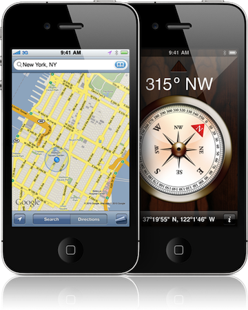
The wording of the statement isn’t clear (some suggest “traffic” may be related to “internet traffic” according to specific locations), but let’s just play along and assume it’s linked to the turn-by-turn navigation software and new mapping features for iOS devices Apple has been rumored to be working on for a very long time. If “traffic” is related to navigation and mobile maps, there’s plenty room for speculation after today’s press release: in the past years, several job listings on Apple’s website hinted at open positions in the iOS team for map engineers and navigation experts, suggesting that Apple was working on its own proprietary solution to ditch Google Maps on the iPhone, iPod touch and iPad. The acquisitions of mapping companies Placebase and Poly9 in 2009 and 2010, respectively, gave some credence to the reports that pointed at Apple willing to become the next major player in the mobile mapping scene. Read more


Localscope Is Perfect For iPod Or iPhone

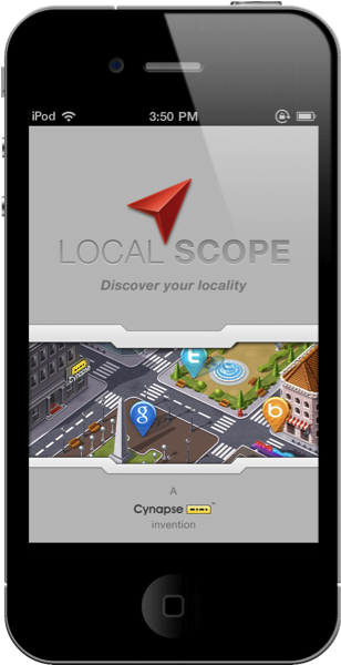
It doesn’t matter whether a GPS signal is available to know what restaurants are nearby, or where the next gas station is. In fact, I’d easily trade Localscope for Google’s Places on Android (and who wants Hotpot when you have Facebook?). You’re never tethered to a single source of information with Google, Bing, Foursquare, Twitter, and Wikimapia for a combination of maps, current events, and augmented reality. Talk about holy wowza! And the thing is, Localscope is incredibly pretty. It’s the iPhone companion you’ll want on your homescreen if not in a nearby folder, and we’re going to run through some of the features that make this client worth its weight in bacon.

Read more


Turn By Turn Voice Navigation Coming To iOS Maps via Jailbreak

A new Cydia tweak being developed by InfectionFX and TheZimm will add native turn-by-turn voice navigation to the Maps application for iPhone. A few alternatives like MapQuest offer turn-by-turn with voice today in the App Store; this tweak will plug directly into the native Google Maps software for iPhone. While not as full-featured as navigation system offered by Google on Android devices, this option will provide a relatively cheap and useful way to do turn-by-turn voice navigation on iOS without using multiple apps.

[iPhoneDownloadBlog via RazorianFly] Read more


Localscope 1.1 Integrates Navigon MobileNavigator For The Ultimate Find & Drive Combo

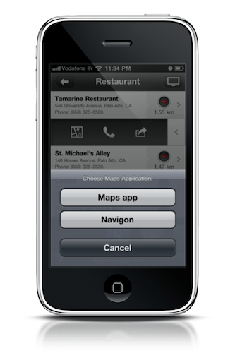
Localscope is well known for its location based discovery prowess, helping you gather information about your current location thanks to the combination of augmented reality, geo-meta-search, and social driven capabilities. Comparable to Google’s Places, Localscope enables users to find the nearest hotspots for coffee, movies, and more. As of Localscope 1.1, you can not only find the hip new club in your city, but you can navigate to it as well thanks to Navigon MobileNavigator integration. Swipe across your destination, tap the map, and bring up MobileNavigator so you can quickly reach your destination. Localscope with MobileNavigator brings the functionality that Android has delivered with Places and Navigation Beta to the iPhone: if you own both the applications, the combo presents a terrific way to traverse new landscapes without getting lost.

Localscope can be downloaded from the App Store for $2.99, and Navigon MobileNavigator (USA version) can be downloaded for $39.99.


Where To? for iPhone Gets 3D Augmented Reality

Where To? by Future Tap is one of the most popular apps ever released for the iPhone. In fact, I remember buying the app years ago on my original iPhone, and I still have it. Where To?, like many other alternatives that eventually came out in the App Store, gives you detailed information of nearby points of interest using the iPhone’s built-in GPS technology and Google Maps. It features a popular and unique “click-wheel” interface that Apple even used in patents to describe functionalities of iOS apps and, overall, it’s powered by a great design that’s really a pleasure to look at.

A few minutes ago, Where To? got a major update that introduces a neat 3D Augmented Reality feature I’m just playing around with as we speak. The Future Tap developers added this new option as a $0.99 in-app purchase that’s a no-brainer for as much as it’s well realized and perfectly consistent with the rest of the app. As the app fetches your location and provides you a list of POIs, you can switch to the usual map view and you’ll notice a new “eye” icon in the bottom toolbar that activates Augmented Reality. Unlike other AR software, Where To’s 3D implementation stands out because of the use of OpenGL that brings smooth animations to the reality layer captured by the iPhone’s camera. When pointing the iPhone, the app will create a virtual grid that displays POIs as boxes, all based on the distance between the user and the target. The developers explain:

Our solution: First, results are displayed in a real 3D world and their size and stacking order depends on the distance. Then, you can zoom in and out using the gestures already known from the map: Double-tap to zoom in, two-finger-tap to zoom out, pinch for fine grained zooming. Zooming of course affects the camera picture as well.

Where To? 3.5 also uses the gyroscope for much smoother AR animations and location info. In my initial tests, I’ve found the system to work exactly as the developers described it in the introductory blog post; you can zoom it and pan out with two fingers, tap on a POI’s box to get to the usual portrait view. The UI is gorgeous.

Where To? 3.5 is available here at $2.99. To see the app in action, check out the promo video below. Read more


The Cartographer Brings Beautiful Vintage Maps To The iPhone

They say art is about the details, and geeks say the same about Apple’s products. Are Apple’s gadgets and computers a new form of art then? I don’t know, but sure they are an example of excellent industrial design that meets consumers’ tastes and needs. So what could ever happen if art as we know it joined Apple’s design as an app for the iPhone?

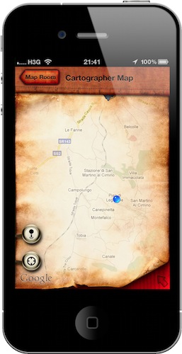
I’m pretty sure something like The Cartographer for iPhone would happen. A simple app that turns Google Maps into a beautiful experience based on the maps that once were. Read more


Apple Using Own Location Services in 3.2 & Higher

After the purchase of Poly9 and Placebase, you’d think Apple would start implementing their own Map services right? I think you’d be correct. Something’s that flown under the radar is the fact that in April, Apple started dropping the location based services of Skyhook Wireless and Google in order to implement their own. As of iPhone OS 3.2 and now iOS 4, Apple is in complete control of the location services used in the iPhone, iPod touch, and iPad.

[via TechCrunch]


Apple Purchases Online Mapping Company, Poly9

The Android comes with free Google Maps Navigation. iPhone owners will often downplay this feature of Android handsets, but for me it’s the definitive feature that has kept me from using an iPhone handset for my daily needs. Google Maps Navigation is super convenient to have, and I’m looking forward to when Apple releases a similar, competitive product of its own (if they ever will that is). As Apple’s and Google’s relationship dissolves in the smart-phone market, they may be looking to absolve themselves of Google’s services at some point down the road. Mainly their Maps feature.

Read more